
 As
active members of the largest ATV club in Nevada, my wife and I have ridden
a lot of miles in our home state. The founders of our club, like us a retired
couple in their early 60's, suggested riding ATV's the length of our state
from Arizona to Idaho. We would be riding through one of the least populated
areas of the country, and we would be doing it without a support vehicle.
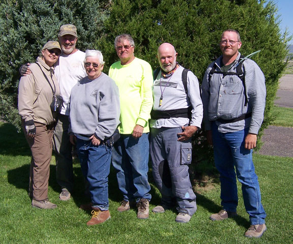
Who could pass up an opportunity like that? We recruited two more club members:
a 37 year old restaurant owner who is a recent cancer survivor, and a 74 year
old retiree who in his comparative youth (mid-50's) raced dirt bikes and even
trophied in the Barstow to Vegas run. Our team was complete now that
we added "youth and experience"!
As
active members of the largest ATV club in Nevada, my wife and I have ridden
a lot of miles in our home state. The founders of our club, like us a retired
couple in their early 60's, suggested riding ATV's the length of our state
from Arizona to Idaho. We would be riding through one of the least populated
areas of the country, and we would be doing it without a support vehicle.
Who could pass up an opportunity like that? We recruited two more club members:
a 37 year old restaurant owner who is a recent cancer survivor, and a 74 year
old retiree who in his comparative youth (mid-50's) raced dirt bikes and even
trophied in the Barstow to Vegas run. Our team was complete now that
we added "youth and experience"!
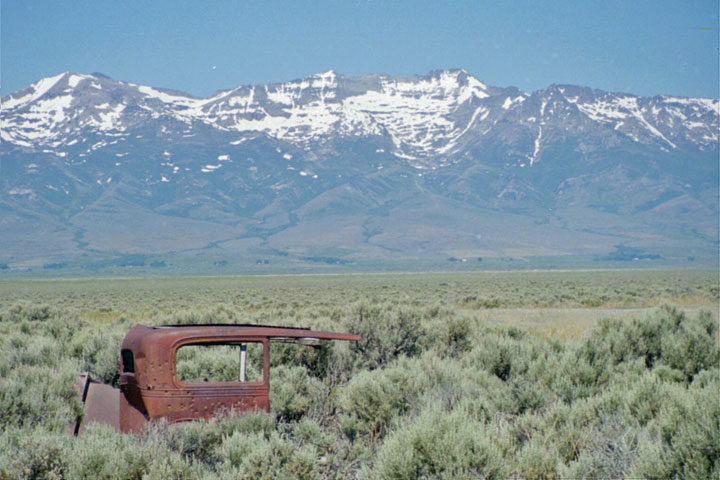
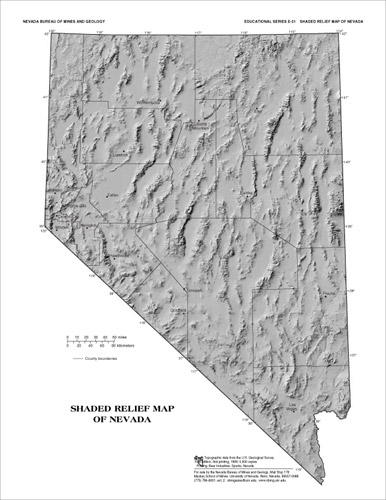 What
is the country like? Nevada's topography is called Basin and Range.
The Basin part means that Nevada is not in the Atlantic or Pacific
watershed. Forget that Continental Divide concept; rainfall here doesn't drain
into any ocean. The Range part consists of a number of parallel mountain
ranges with 9,000' to 11,000' ridges separated by long, narrow valleys with
floor elevations of around 5,000'. The weather extremes in this country presented
us with a dilemma: leave too soon and the mountain passes would be blocked
by snow; leave too late and the desert heat would kill us. Since the best
scenery is likely to be found in the mountains, we scheduled our trip for
the early summer and moved our starting point a few miles north so we could
remain cool in the higher elevations (never dipping below that mile-high point
of which Denver is so proud).
What
is the country like? Nevada's topography is called Basin and Range.
The Basin part means that Nevada is not in the Atlantic or Pacific
watershed. Forget that Continental Divide concept; rainfall here doesn't drain
into any ocean. The Range part consists of a number of parallel mountain
ranges with 9,000' to 11,000' ridges separated by long, narrow valleys with
floor elevations of around 5,000'. The weather extremes in this country presented
us with a dilemma: leave too soon and the mountain passes would be blocked
by snow; leave too late and the desert heat would kill us. Since the best
scenery is likely to be found in the mountains, we scheduled our trip for
the early summer and moved our starting point a few miles north so we could
remain cool in the higher elevations (never dipping below that mile-high point
of which Denver is so proud).
 How
remote would we be? Nevada is the seventh largest state at 110,567 square
miles of which the federal government controls 83%. The 2000 census reported
a state population of just under 2 million people, with 1.7 million of those
residing in the two counties containing Las Vegas and Reno. Interestingly
enough, population in the counties that we would be passing through has not
changed significantly since Nevada became a state in 1864. Our route would
take us through only 3 counties: Lincoln county, which is larger than 8 of
the states and has a population density of 4/10 of a person per square mile,
currently 4,200 people where the 1870 population was 3,000; White Pine county,
which is larger than 5 of the states and has a population density of 1 person
per square mile, currently 9,100 people where the 1870 population was 7,200;
and Elko county, which is larger than 9 of the states and has a burgeoning
population of 45,000 people, very few of whom live in the section through
which we would be traveling.
How
remote would we be? Nevada is the seventh largest state at 110,567 square
miles of which the federal government controls 83%. The 2000 census reported
a state population of just under 2 million people, with 1.7 million of those
residing in the two counties containing Las Vegas and Reno. Interestingly
enough, population in the counties that we would be passing through has not
changed significantly since Nevada became a state in 1864. Our route would
take us through only 3 counties: Lincoln county, which is larger than 8 of
the states and has a population density of 4/10 of a person per square mile,
currently 4,200 people where the 1870 population was 3,000; White Pine county,
which is larger than 5 of the states and has a population density of 1 person
per square mile, currently 9,100 people where the 1870 population was 7,200;
and Elko county, which is larger than 9 of the states and has a burgeoning
population of 45,000 people, very few of whom live in the section through
which we would be traveling.
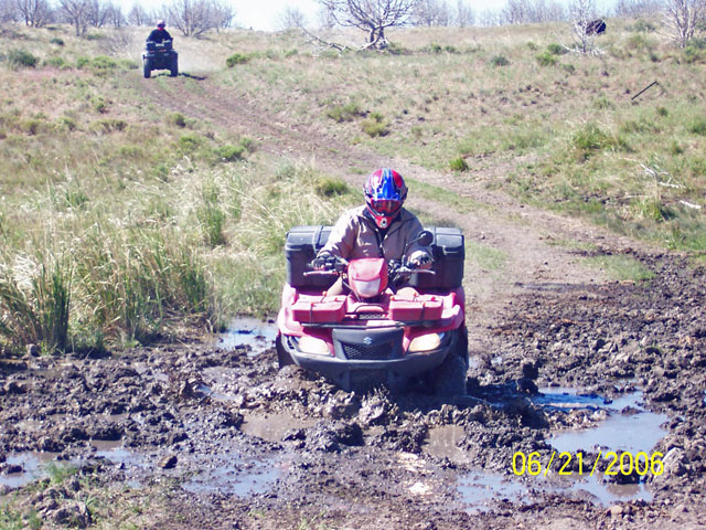
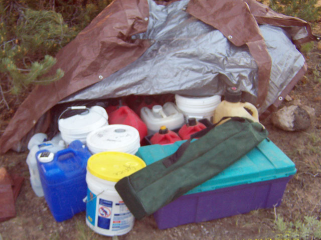 This
sparse population means a scarcity of services. Motels, restaurants and gas
stations would only be available in the two towns (Ely and Wells) which lie
along our direct route. For obvious reasons we planned to arrive in those
towns at days-end. With a little creative routing, we arranged to spend another
"civilized" night at one of those roadside stops that exists only to keep
the highway department from having to erect a sign saying "next gas 200 miles".
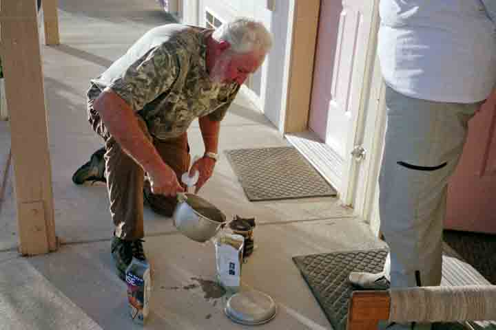
Amenities at that roadside stop consist of a motel and gas station. The lack
of restaurant facilities forced us to prepare our
own dinner. For the remaining nights, we cached water, food, gasoline and
camping equipment at primitive camping locations along our route. Cooking
in camp required some improvising as well. One
benefit to traveling in such a remote area is that there would be very little
risk of someone plundering our caches. Critter plunder, on the other hand,
remained a distinct possibility.
This
sparse population means a scarcity of services. Motels, restaurants and gas
stations would only be available in the two towns (Ely and Wells) which lie
along our direct route. For obvious reasons we planned to arrive in those
towns at days-end. With a little creative routing, we arranged to spend another
"civilized" night at one of those roadside stops that exists only to keep
the highway department from having to erect a sign saying "next gas 200 miles".
Amenities at that roadside stop consist of a motel and gas station. The lack
of restaurant facilities forced us to prepare our
own dinner. For the remaining nights, we cached water, food, gasoline and
camping equipment at primitive camping locations along our route. Cooking
in camp required some improvising as well. One
benefit to traveling in such a remote area is that there would be very little
risk of someone plundering our caches. Critter plunder, on the other hand,
remained a distinct possibility.
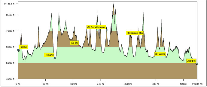
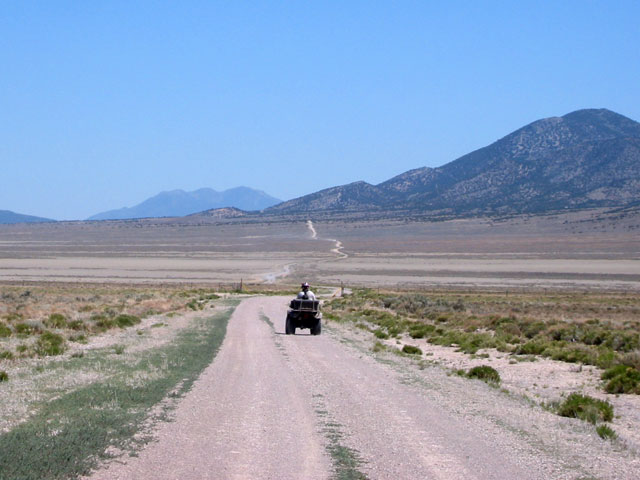
 We
decided to begin our ride in the old mining town of Pioche (Local Lore: 75
people were buried here before the first died of natural causes) and end in
the border town of Jackpot. There are only two north-south highways running
the length of Nevada, US-93 in the east and US-95 in the west. Both are 2-lane
roads that follow valleys whenever possible. Neither takes a direct route
because they were originally built to connect old mining towns in different
mountain ranges. An automobile following US-93 from Pioche to Jackpot would
cover 312 miles. Our planned route, following dirt roads and designated ATV
trails, indicated a distance of 520 miles. As a result of both accidental
and intentional diversions, our actual ride distance would come in at 640
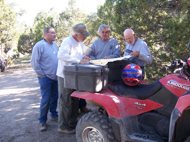
miles. There are no road signs in the desert! We found roads that looked good
on our maps but no longer existed, and we sometimes ended up traveling roads
and trails that were not shown on any maps. We began our trip with a philosophy
that "there are no wrong roads"; when we found ourselves off course we simply
rerouted to the next destination. After the planned 100 mile ride on the first
day turned into 150, retracing our steps in the event of error didn't sound
like such a bad idea!
We
decided to begin our ride in the old mining town of Pioche (Local Lore: 75
people were buried here before the first died of natural causes) and end in
the border town of Jackpot. There are only two north-south highways running
the length of Nevada, US-93 in the east and US-95 in the west. Both are 2-lane
roads that follow valleys whenever possible. Neither takes a direct route
because they were originally built to connect old mining towns in different
mountain ranges. An automobile following US-93 from Pioche to Jackpot would
cover 312 miles. Our planned route, following dirt roads and designated ATV
trails, indicated a distance of 520 miles. As a result of both accidental
and intentional diversions, our actual ride distance would come in at 640
miles. There are no road signs in the desert! We found roads that looked good
on our maps but no longer existed, and we sometimes ended up traveling roads
and trails that were not shown on any maps. We began our trip with a philosophy
that "there are no wrong roads"; when we found ourselves off course we simply
rerouted to the next destination. After the planned 100 mile ride on the first
day turned into 150, retracing our steps in the event of error didn't sound
like such a bad idea!
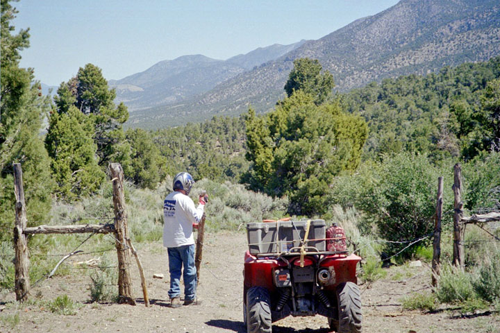
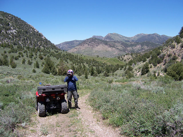
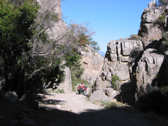
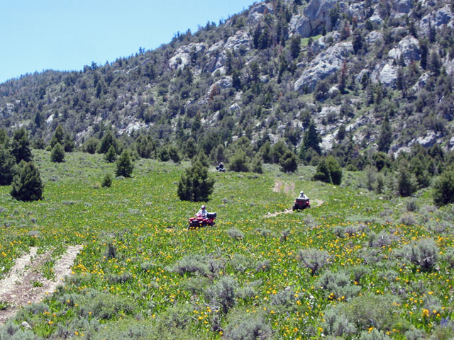
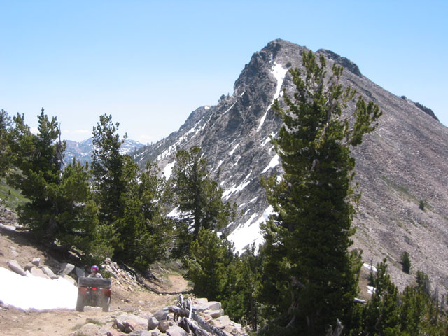
 At
times we found ourselves riding segments of historic transcontinental
routes: the Pony Express Trail, the California trail, the Lincoln Highway,
the Transcontinental Railroad, and the first transcontinental telegraph line.
Each trail or dirt road brought unique vistas. People driving on paved roads
through the valleys of Nevada would never suspect that such spectacular scenery
exists in the mountains on both side of the highway. They would miss the experience
of negotiating narrow rocky passes climbing those
mountains, and they would never get to see the fields of wild
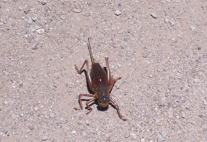
flowers blooming in narrow elevation bands along the way. The local wildlife
made its appearance every day too. We saw wild horses, elk, mule deer, and
pronghorn antelope. At one point, we ran into an infestation of Mormon
crickets cannibalizing their brethren in heaps of carcasses along the
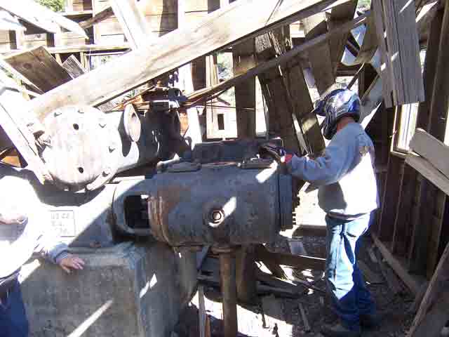
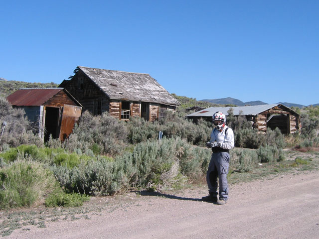
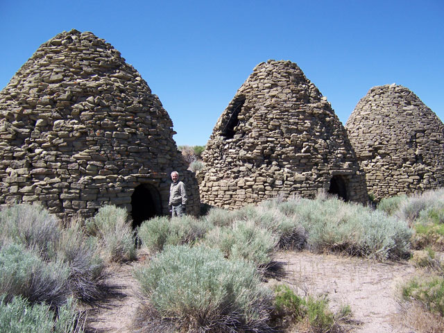
trail. We lost track of the number of ghost towns
that we came across. Plenty of time was allotted to explore abandoned mining
operations, homesteads and even a few charcoal
kilns. It was easy to see how rural Nevada's 1870 population could rival
21st century levels.
At
times we found ourselves riding segments of historic transcontinental
routes: the Pony Express Trail, the California trail, the Lincoln Highway,
the Transcontinental Railroad, and the first transcontinental telegraph line.
Each trail or dirt road brought unique vistas. People driving on paved roads
through the valleys of Nevada would never suspect that such spectacular scenery
exists in the mountains on both side of the highway. They would miss the experience
of negotiating narrow rocky passes climbing those
mountains, and they would never get to see the fields of wild
flowers blooming in narrow elevation bands along the way. The local wildlife
made its appearance every day too. We saw wild horses, elk, mule deer, and
pronghorn antelope. At one point, we ran into an infestation of Mormon
crickets cannibalizing their brethren in heaps of carcasses along the
trail. We lost track of the number of ghost towns
that we came across. Plenty of time was allotted to explore abandoned mining
operations, homesteads and even a few charcoal
kilns. It was easy to see how rural Nevada's 1870 population could rival
21st century levels.
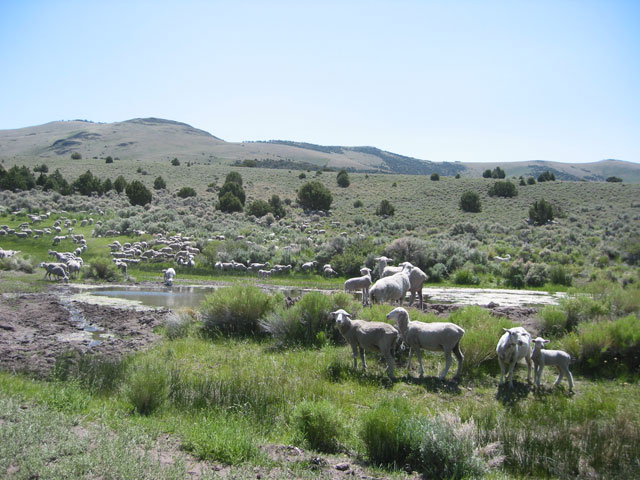
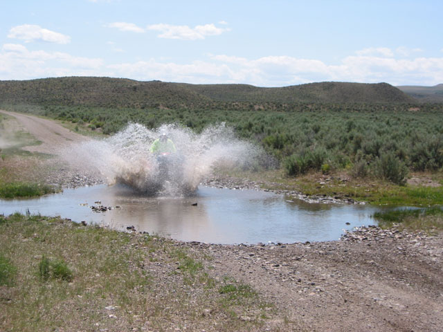 With
total precipitation averaging less than nine inches per year, Nevada is the
most arid state in the nation. Aside from a few muddy
springs, most of which were surrounded by cattle or sheep,
the first real water that we saw was a creek 600 miles into our trip. Needless
to say, we stopped for a commemorative photo
before making a high speed run through the stream to thoroughly soak ourselves
in the splash.
With
total precipitation averaging less than nine inches per year, Nevada is the
most arid state in the nation. Aside from a few muddy
springs, most of which were surrounded by cattle or sheep,
the first real water that we saw was a creek 600 miles into our trip. Needless
to say, we stopped for a commemorative photo
before making a high speed run through the stream to thoroughly soak ourselves
in the splash.
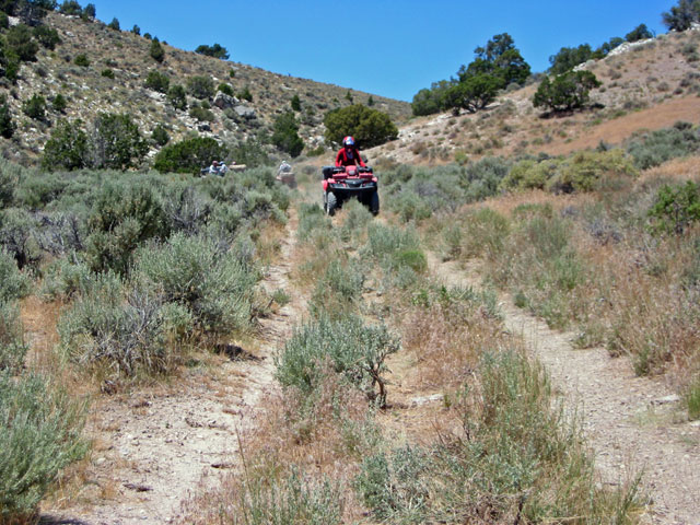 When
we reached the Elko county line, the scenery along our route was a little
less spectacular and the trails were a lot less accommodating. The only passages
we could find through the hills were abandoned pickup truck roads with a wide
strip of sagebrush down the center. The track on an ATV is a bit over half
a pickup truck's width; there was no way to avoid one side or the other bouncing
over the twisted roots. We sent one of our guys up the highest hill to look
for a "real" road. He spotted a train track that "sort of" went in the right
direction. We were hoping for an access road paralleling the tracks. What
we found was an abandoned rail line and more of the dreaded sagebrush. For
quite a while the GPS had been telling us that we were only 10 miles from
our cache; it was just on the other side of the mountain. When we finally
bounced our way over to a decent road, we checked the GPS and we were STILL
10 miles away. We followed that good road along the base of the mountain for
half an hour and, you guessed it, we were STILL 10 miles from camp with no
apparent way across the mountain. Just then the hidden pass appeared and we
had a smooth, fast ride into camp.
When
we reached the Elko county line, the scenery along our route was a little
less spectacular and the trails were a lot less accommodating. The only passages
we could find through the hills were abandoned pickup truck roads with a wide
strip of sagebrush down the center. The track on an ATV is a bit over half
a pickup truck's width; there was no way to avoid one side or the other bouncing
over the twisted roots. We sent one of our guys up the highest hill to look
for a "real" road. He spotted a train track that "sort of" went in the right
direction. We were hoping for an access road paralleling the tracks. What
we found was an abandoned rail line and more of the dreaded sagebrush. For
quite a while the GPS had been telling us that we were only 10 miles from
our cache; it was just on the other side of the mountain. When we finally
bounced our way over to a decent road, we checked the GPS and we were STILL
10 miles away. We followed that good road along the base of the mountain for
half an hour and, you guessed it, we were STILL 10 miles from camp with no
apparent way across the mountain. Just then the hidden pass appeared and we
had a smooth, fast ride into camp.
 The
next day's was to be our last with 80 miles to go via unknown trails crossing
a final range of hills. It wasn't long before the ride degenerated into more
sagebrush. We consulted the map and found a Back Country Byway called the
California Trail that led in the right direction. This famous route was laid
out by 19th century travelers going from the Oregon Trail along the Snake
River to the Humboldt River which ran across Nevada toward California (and
eventually died in one of those Basin valleys). Our current location was near
the headwaters of the Humboldt; we could follow the trail backwards to the
Idaho border then find a road leading west to our destination. The vote was
unanimous! We might have shunned a graded road on Day 1 but it was looking
pretty good on Day 6, at least compared to the alternative. It was on this
road that we saw the only other vehicle that we ran across on our 640 mile
trek outside of the two towns and two highway crossings.
The
next day's was to be our last with 80 miles to go via unknown trails crossing
a final range of hills. It wasn't long before the ride degenerated into more
sagebrush. We consulted the map and found a Back Country Byway called the
California Trail that led in the right direction. This famous route was laid
out by 19th century travelers going from the Oregon Trail along the Snake
River to the Humboldt River which ran across Nevada toward California (and
eventually died in one of those Basin valleys). Our current location was near
the headwaters of the Humboldt; we could follow the trail backwards to the
Idaho border then find a road leading west to our destination. The vote was
unanimous! We might have shunned a graded road on Day 1 but it was looking
pretty good on Day 6, at least compared to the alternative. It was on this
road that we saw the only other vehicle that we ran across on our 640 mile
trek outside of the two towns and two highway crossings.
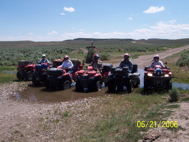
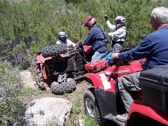
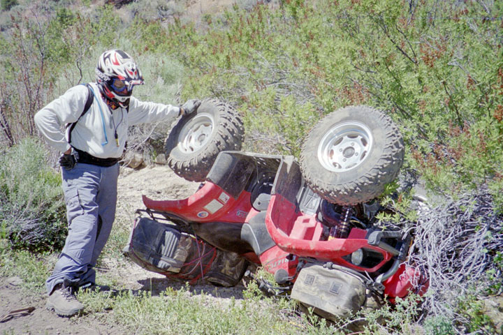 Our
RV's were waiting for us in Jackpot where we had dropped them off the previous
week. We all headed for the casino buffet and high-fived to a very successful
adventure. No one got hurt, no one broke down, and we only had one "winching
opportunity" Next year we plan to ride across Nevada from west to
east following the route of the Pony Express through a section of country
that is virtually unchanged from the days when Buffalo Bill rode it. Hopefully,
our having survived this year's adventure will embolden other club members
to join us on the next one.
Our
RV's were waiting for us in Jackpot where we had dropped them off the previous
week. We all headed for the casino buffet and high-fived to a very successful
adventure. No one got hurt, no one broke down, and we only had one "winching
opportunity" Next year we plan to ride across Nevada from west to
east following the route of the Pony Express through a section of country
that is virtually unchanged from the days when Buffalo Bill rode it. Hopefully,
our having survived this year's adventure will embolden other club members
to join us on the next one.
Footnote: After a couple of days rest and laundry chores in Jackpot, four of us loaded up the ATV's and headed for the mountains of Idaho to meet other club members and ride another 400 miles or so before heading home.